Global Positioning System (GPS)
![]()
GPS will be history soon VPS is coming. VPS vs GPS. This is a space-based navigation system that gives location and time information to any receiver of the GPS on the ground. In fact, the concept of this system was first envisioned by the United States Department of Defense as that tool that was to be used by the military alone, but it ended up being made available for public use during the 1980s. A GPS requires a constellation of some 30 satellites orbiting Earth. They continually broadcast signals received by a GPS receiver on the ground.
Each member of this GPS constellation is transmitting information about where it is and the absolute time at which it sent its signal. A GPS receiver might be a cell phone, a car or just a GPS unit. It calculates its location by how many seconds away some signals emitted from several satellites it can reach will be. One needs at least four satellites to establish location. The information acquired above will thus inform the GPS receiver its latitude, longitude, altitude, and even speed.
With all these applications, all the vehicles, aircraft, or ships have navigation systems which perform work following this system. They go further to measure the surface of Earth by doing land surveys or engaging themselves in the scientific studies of the landscape of Earth.
With such applications close to a very few other services in the market, including mobile apps, ride-hailing apps, location-based apps, etc. GPS has become a part of every individual’s life.
Visual Positioning System (VPS)
Visual Positioning System is relatively a new technology wherein GPS is combined with visual data from a camera or sensor in order to achieve better location accuracy and context. VPS bases the data it uses to decide its location around the environment based on visual data gained through information related to any landmarks, buildings or even specific items. This does not have problems with updated functionality as GPS does; therefore, VPS is helpful especially in a weak or obstructed GPS environment, for example indoors or in highly populated urban areas with high-rise buildings.
VPS works generally through comparing what the image or video captured by a camera is with a precompiled database of images or 3D maps. Where there are visual signs detected, VPS aligns those with location data to ensure an accurate perception of the device’s location. This method can even be precise to a few centimeters in inaccessible situations where GPS fails. VPS also offers orientation such that the user will know which direction he faces.
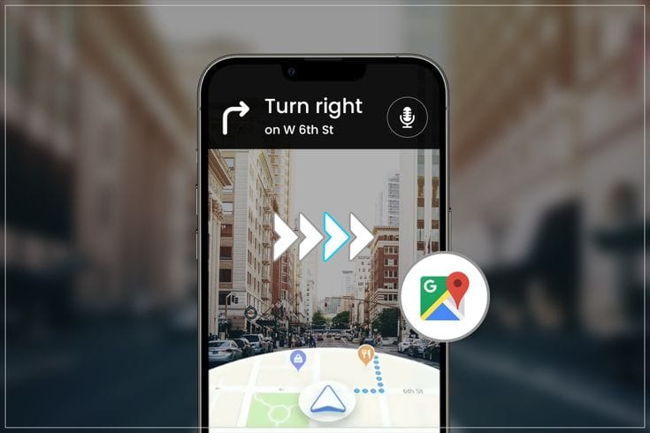
Probably, the most important applications of VPS are in AR. A great case here is Google’s walking directions in AR, which uses VPS to overlay directions and information over a live view of the environment captured by the camera of a smartphone. That would be highly useful in navigating complex environments such as unknown cities or malls by giving the user direct real-time visual cues.
VPS may also find an application in the autonomous car, robotics, and drones, making those machines move more precisely about an environment to “see” and understand their surroundings.
Differences and Synergies
Even though both GPS and VPS promise to offer an idea of location-based information, they work fundamentally different. GPS relies upon satellite signals and is global in reach but suffers in dense cities, indoors, and with heavy tree coverage. However, VPS processes visual information and gives better accuracy for location but can meaningfully function only over a rich database of images or maps. The GPS and VPS are, more often than not, used together in most applications to provide both accurate and context-aware navigation and positioning.
Summary Conclusion The GPS is considered the technology backbone for full-globe navigation; however, VPS has superior positioning precision when used in more demanding applications involving greater complexity of view or signal.